
Photo Record
Images
Metadata
Title |
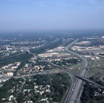
Aerial View of 127th Street and Cicero Avenue |
Accession Number |
2008.070.060 |
Object Name |
Transparency, Slide |
Description |
This is slide is an aerial view of the intersection of Cicero Avenue and 127th Street circa 1982 looking from the southeast to the northwest. Cicero Avenue is running left (south) to right (north) through the lower one-third of the picture. 127th Street is running east and west from the right lower corner of the picture towards the upper middle of the picture. The bridge spanning the Cal-Sag Canal is clearly visible in the middle left of the picture. The large multi-lane road curving through the picture is the I-294 Tollway. Burr Oak Cemetery is visible in the left lower corner of the picture. A red and white Alsip water tower can be seen in the far right of the picture and Oak Lawn is only visible in the far distance marked by what appears to be a white water tower seen left of and up from the Alsip tower. |
Date |
05/--/1982 |
Classification |
Streets Cemeteries Homes |
Search Terms |
Photograph Picture Slide Waterways Intersections Houses |