
Photo Record
Images
Metadata
Title |
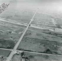
Howell Airport |
Accession Number |
2021.039.003 |
Object Name |
Print, Photographic |
Description |
This is an aerial photograph of Howell Airport located in Crestwood on the southwest corner of Cal Sag Road and Cicero Avenue. Looking north, Cicero Avenue runs from top to bottom and the airfield is visible on the left. The area is surrounded by numerous farm fields while the Cal-Sag Channel runs from left to right. The airport opened in 1941 and closed in 1989. |
Date |
02/20/1954 |
Print size |
11" x 14" |
Classification |
Airports Streets Farms & Farming Agriculture |
Search Terms |
Photos Photographs Pictures Pilots Flight Aircraft Airplanes |