
Photo Record
Images
Metadata
Title |
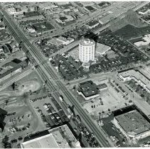
Aerial View of Cicero Avenue from Southwest Hwy to 95th Street |
Accession Number |
2002.009.019 |
Object Name |
Print, Photographic |
Description |
This is an aerial photograph of Cicero Avenue between Southwest Highway and 95th Street. The intersection of Southwest Highway and Cicero Avenue is seen in the left top of the photo. Southwest Highway runs left (southwest) to right (northeast) at the top of the photo. Cicero Avenue runs from the top left (north) to the bottom right (south) of the photo. Railroad tracks run parallel with Southwest Highway. In the bottom middle of the photo, the Pete Georges Chevrolet building is partially visible surrounded by dealership lots. On the left, Old Kent Bank (formerly First National Bank of Evergreen Park) and its parking lot is partially visible. To the north of the railroad tracks, the D-Lux Motel located at 4811 W. Columbus Drive is visible. and A Marathon gas station occupies the southwest corner of the intersection of Cicero and Southwest Highway. On the right, the Kole Pontiac dealership, the Oak Lawn Hilton at 94th Street and Cicero (9333 South Cicero Avenue), and St. Paul Federal Bank is at 9401 S. Cicero are visible. St. Paul Lutheran Church and School are partially visible to the right (east) of the Hilton. The Coral Plaza shopping center is seen in the far right of the picture. A new Walgreens store is under construction at 4740 W. 95th Street, on the northeast corner of the intersection. |
Date |
Circa 1999 |
Print size |
8" x 10" |
Classification |
Streets Business & Commerce Aerial Views Automobiles Vehicles Retail Restaurants Hotels Churches & Temples/Exterior Schools Railroads Transportation Health Banking & Financial Structures |
Search Terms |
Photos Photographs Pictures Businesses Dealerships Shopping Trains Medical Pharmacy Motels Inns Banks |