
Archive Record
Images
Metadata
Title |
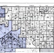
1974 Redistricting Proposal Maps |
Accession Number |
2015.571.028 |
Object Name |
Map |
Scope & Content |
Maps outlining the boundaries of proposed changes to the Village's districts in 1974. Maps were submitted by Ernest "Ernie" Kolb, Fred M. Dumke, and Dave Morris. |
Date |
07/14/1972 |
Link |
Click Here to View the PDF. |
Classification |
Government & Politics Streets Political Activities Elections |
Search Terms |
Voting Maps Charts Atlas |