
Archive Record
Images
Metadata
Title |
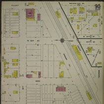
1911 Map of Oak Lawn |
Accession Number |
2019.034.001 |
Object Name |
Map |
Scope & Content |
This is a 1911 map of Oak Lawn produced by the Sanborn Fire Insurance Company. At this time the population was listed at 300 residents. Locations on the map include the Brandt Building at 5131 West 95th Street, the Olaf Larsen Coal Shed (spelled Larson), Oak Lawn Methodist Episcopal Church at 9536 South Minnick Avenue, First Congregational Church at 9424 South 54th Avenue, Trinity Evangelical Lutheran Church at 5000 West 95th Street, Cook (Oak Lawn) School at 9526 South Cook Avenue, Wabash Train Depot, Glaser Kohn Pickle Company, Hoffman Blacksmith Shop near 9509 South Minnick Avenue, horse sheds, L.E. Crandalls Subdivision and more. This item is courtesy of Library of Congress. |
Date |
--/--/1911 |
Link |
Click Here to View the PDF. |
Classification |
Streets Business & Commerce Churches & Temples Religion Religious Organizations Schools Education Railroads Transportation Animals Homes |
Search Terms |
Maps Charts Businesses Trains Houses |