
Archive Record
Images
Metadata
Title |
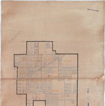
1950 Map of Oak Lawn |
Accession Number |
2020.228.001 |
Object Name |
Map |
Scope & Content |
This item is a map of Oak Lawn produced in 1950 by the Bureau of the Census. It divides Oak Lawn into different enumeration districts. This item is courtesy of the National Archives and Records Administration. |
Date |
--/--/1950 |
Link |
Click Here to View the PDF. |
Classification |
Streets Government & Politics |
Search Terms |
Maps Charts Population |