
Archive Record
Images
Metadata
Title |
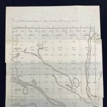
Plat of Township No 37 North of the Baseline, Range No 13 East of the 3rd Principal Meridian |
Accession Number |
2008.054.001 |
Object Name |
Map |
Scope & Content |
This is a copy of a map of Worth Township drawn up by the Surveyors Office of St. Louis, on July 31st, 1834. Present day Oak Lawn exists in sections eight and nine. Oak Lawn Creek and Stony Creek are visible in this area as well. |
Date |
07/31/1834 |
Year Range from |
1834 |
Year Range to |
1834 |
Link |
Click Here to View the PDF. |
Classification |
Maps Water Townships Creeks & Streams |
Search Terms |
Maps Worth Township |