
Archive Record
Images

Metadata
Title |
Residential Security Map |
Accession Number |
2020.167.001 |
Object Name |
Map |
Scope & Content |
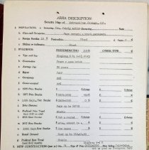
This item is a residential security map of Chicago and its suburbs produced between 1939 and 1940. It was created by the Division of Research and Statistics of the Federal Home Loan Bank Board, a sister agency to the Federal Housing Authority. The FHA was created during the Great Depression to address the drastic fall in home loans and ownership. As part of this process, urban areas across the United States were designated and color coded using racist methods by raking the "desirability" of various races. According to the website Digital Chicago History, "Predominantly European American neighborhoods were ranked the most desirable and lowest risk for mortgage lending, designated as green on the map. Blue areas were also European American neighborhoods but inhabited by Jewish, Irish, and Italian Americans, and was considered stable and upwardly mobile, thus representing a relatively lower risk. Neighborhoods with predominantly working-class Whites were designated Yellow and represented slightly higher lending risk and therefore, less desirable than the green and blue areas. African American and Mexican American neighborhoods were marked as "Red" areas with the highest risk. This ranking had regard for wealth, class, education, and other measures of credit worthiness. This process has come to be dubbed "Redlining." In this particular map, Oak Lawn in colored yellow and many nearby communities are colored red. |
Year Range from |
1939 |
Year Range to |
1940 |
Link |
Click Here to View the PDF. |
Classification |
Streets Homes Neighborhood |
Search Terms |
Maps Charts Houses New Deal Racism African American Experience Black History |